
 |
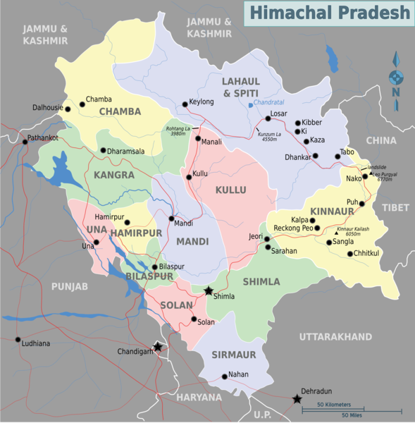
| Neighbouring States of Himachal Pradesh/Source:Wikimedia |
On the northern side, Chamba and Lahaul-Spiti forms the inter-state boundary with Ladakh and Jammu region of Jammu and Kashmir.
On the western side, Chamba, Kangra, Una, Bilaspur and Solan forms the Himachal Pradesh boundaries with Punjab.
On the southern side, Nahan (Sirmaur) makes the state boundary with Haryana and on the south-eastern side, Shimla, Sirmaur and Kinnaur makes up the state boundaries with Uttrakhand.
Interestingly, near Paonta Sahib (Sirmaur), Himachal Pradesh forms a short boundary with Uttar Pradesh. At this point, it forms the tri-junction of Uttarakhand, Uttar Pradesh and Himachal Pradesh. Similarly at few kilometers north, a tri-junction of Haryana, Himachal Pradesh and Uttar Pradesh can be located.
Neighbouring Districts of Himachali Districts
Kinnaur: Lahaul-Spiti, Kullu and Shimla
Sirmaur: Shimla and Solan
Lahaul-Spiti: Chamba, Kangra, Kullu and Kinnaur
Chamba: Kangra and Lahaul-Spiti
Kangra: Chamba, Lahaul-Spiti, Kullu, Mandi, Hamirpur and Una
Shimla: Solan, Sirmaur, Mandi, Kullu and and Kinnaur
Mandi: Kullu, Kangra, Hamirpur, Bilaspur, Solan and Shimla
Kullu: Lahaul-Spiti, Kangra, Mandi, Shimla and Kinnaur
Hamirpur: Kangra, Mandi, Bilaspur and Una
Bilaspur: Una, Hamirpur, Mandi and Solan
Solan: Bilaspur, Mandi, Shimla and Sirmaur
Una: Bilaspur, Kangra and Hamirpur