 |
| Agroclimatic Zones of Gujarat |
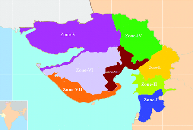
The state of Gujarat falls under the Zone 13 of Agroclimatic Zones of India. The meso zone is further divided into eight zones on the basis of climate, rainfall, terrain and soil.
The eight agroclimatic zones of Gujarat are
Zone I
Lower Southern Gujarat
Region: Dang; parts of Valsad; parts of Surat (Vyara, Uchchhal, Songadh, Mahuva talukas)
Climate: Semiarid to dry subhumid
Average Rainfall: 1500 mm and above
Soil: Deep black clayey
Zone II
Upper Southern Gujarat
Region: Parts of Valsad (Navsari and Gandavi talukas); parts of Surat (Kamrej, Nizar, Palsana, Bardoli, Mangrol and Mandvi talukas) and parts of Bharuch (Ankleshwar, Valia, Rajpipla, Dediapada and Sagabara talukas).
Climate: Semiarid to dry subhumid
Average Rainfall: 1000-1500 mm
Soil: Deep black clayey with patches of alluvial and lateriate soil
Zone III
Middle Gujarat
Region: Panchmahal; Vadodara; parts of Bharuch (Bharuch Amod and Jambusar talukas) and Borsad taluka of Kheda District.
Climate: Semiarid
Average Rainfall: 800-1000 mm
Soil: Deep black, medium black to loamy
Zone IV
North Gujarat
Region: Mehsana, Ahmedabad, Banaskantha; Sabarkantha; Kheda (except Borsad taluka); parts of Khambhat (Matar taluka)
Climate: Arid to semiarid
Average Rainfall: 625-875 mm
Soil: Sandy loam to sandy
Zone V
Bhal and Coastal Gujarat
Region: Area around the gulf of Khambhat and Bhal, Olpad taluka of Surat; Hansot and Wagra talukas of Bharuch District; Dholka and Dhandhuka talukas of Ahmedabad District; Vallabhipur and Bhavnagar talukas of Bhavnagar District; Limbdi talukas of Surendranagar.
Climate: Dry subhumid
Average Rainfall: 625-1000 mm
Soil: Medium black, saline
Zone VI
Southern Sourashtra
Region: Junaggadh; parts of Bhavnagar (Sihori, Ghogha, Savarkundla, Gariadhar, Palitana, Talaja and Mahuva talukas), parts of Amreli (Dhari, Kodinar, Rajula, Jafrabad, Khambha, Amreli, Babra, Lilia, Lathi and Kunkavav talukas); parts of Rajkot (Jetpur, Dhoraji, Upleta and Gondal talukas).
Climate: Dry subhumid
Average Rainfall: 625-750 mm
Soil: Shallow medium black calcereous
Zone VII
Northern Sourashtra
Region: Parts of Rajkot (except Jetpur, Dhoraji, Upleta and Gondal talukas)
Climate: Dry subhumid
Average Rainfall: 400-700 mm
Soil: Shallow medium black
Zone VIII
North West Gujarat
Region: Kutch; Malia taluka of Rajkot; Halvad Dhrangadhra and Dasada talukas of Surendranagar; Sami Harij and Chanasmatalukas of Mehsana; Santalpur, Radhanpur, Kankrej, Diyodar Vav and Tharad talukas of Banaskantha District; and Viramgam and Daskroi city of Ahmedabad District.
Climate: Arid to semiarid
Average Rainfall: 250 mm
Soil: Sandy and saline
Image and Zonal Data Source:
1. Yadav, Archana & Solanki, Reshma & Siliwal, Manju & Kumar, Dolly. (2017). Spiders of Gujarat: A preliminary checklist. Journal of Threatened Taxa. 9. 10697. 10.11609/jott.3042.9.9.10697-10716.
