 |
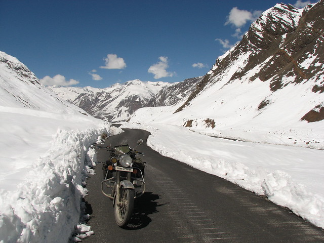
| At Some Unknown Point in Bara-lacha La/Image Source: Abhimanyu |
Bara-lacha La
It lies at an altitude of 4890 meters and connects Lahul and Spiti with Ladakh of Jammu and Kashmir along the Manali-Leh national highway. It is one of the highest motorable pass in the world. The Bhaga river, tributary of Chenab river originates a few kilometer from the pass. The Chandra river, another tributary of Chenab river, also originates from a glacier nearby. It also acts as a water divide between Bhaga river and Yunam river.
Borasu Pass
Borasu Pass lies at an elevation of 5450 meters. It connects Uttrakhand and Himachal Pradesh near Tibet border. It was an ancient trade route between Har ki Doon Valley and Kinnaur Valley.
Chanderkhani Pass
Chanderkhani pass is located in Kullu district of Himachal Pradesh at a height of 3660 meters. It connects Naggar with famous Malana village.
Chanshal Pass
The Chanshal Pass connects Rohru with Dodra Kwar (Shimla district). It lies at the elevation of 3750 meters and known for the seasonable motorable road between its connecting centres Rohru and Dodra Kwar.
Debsa Pass
Debsa Pass is a 5360 metre high mountain pass between Kullu and Spiti. It is discovered only in 1993 by accident, but only crossed in 1995.
Hamta Pass
Hamta Pass is situated at an elevation of 4270 meters on the Pir Panjal range in the Himalayas. It is a small corridor that connects Lahaul's Chandra Valley to Kullu valley.
Indrahar Pass
Indrahar Pass lies in Dhauladhar range of Himalayas at the height of 4342 meters. It connects Kangra and Chamba and forms a natural border between two districts.
Jalori Pass
Jalori Pass connects Banjar with Anni in Kullu district and lies at an altitude of 3120 metre. It opens as early as March and closes as late as November. It is famous for Jalori Mata Temple.
Jalsu Pass
It is one of the easternmost mountain passes of Dhauladhar range connecting Chamba and Kangra valleys. It is located at the altitude of 3425 meters above sea level. It is mostly used by shepherds of Himachali Gaddi tribe.
Kunzum Pass
Kunzum Pass or Kunzum La pass is a high mountain pass at an elevation of 4590 meters above sea level. It connects Kullu valley and Lahul valley with the Spiti valley. There is a 15 km trek from Kunzum Pass to the famous Chandratal lake.
Parang La
It is an ancient route between Spiti and Ladakh. It lies at the altitude of 5600 meters and parallel to Takling La. Tso Moriri Lake lies on its trek route.
Pin Parbati Pass
Pin Parbati Pass connects Parvati Valley of Kullu with Pin Valley of Lahul and Spiti district of Himachal Pradesh. It lies at the altitude of 5319 metre. It was discovered by Sir Louis Dane in search of an alternate route to the Spiti valley in August 1884.
Rohtang Pass
The Rohtang pass, also known as Rohtang La, connects Kullu valley with Lahul and Spiti. It is located at the elevation of 3978 meters and lies 51 km from Manali. Rohtang literally means the land of corpse. Though, it is not difficult to cross the route by foot, but unpredictable snow blizzards make it really hard. The pass also works as the watershed between Chenab and Beas rivers. The Beas river emerges from its southern side whereas a tributary of Chenab emerges from its northern side.
Rupin Pass
Rupin Pass is a high trekking pass at an altitude of 4650 meteres connecting Sangla Valley of Himachal Pradesh with Dhaula in Uttrakhand. Nearby, Sarasvati Glacier at Sarasvotri has been identified as one of the sources of mythical Rigvedic river Saraswati.
Saach Pass
Saach Pass lies at the altitude of 4,420 metre. It connects the Chamba valley with the Pangi valley. It is open from June/July to mid October. It is the shortest route to Killar. It cuts 670 km in travel from Pathankot to Leh.
Shingo La
Shingo La is situated on the border of Jammu and Kashmir and Himachal Pradesh at an height of 5091 metre. It lies on long-distance footpath linking Zanskar and Lahaul. It is used by both locals and trekkers. It is one of the easiest 5000 m and above pass in Himalayas involving no glacier or steep climbing.
Shipki La
Shipki La lies at the height of 3930 meters. It is considered to be an offshoot of ancient Silk routes and connects Kinnaur with Tibet (China). The river which is known as Langqen Zangbo in Tibet enters India from Tibet nearby this pass.
Takling La
Takling La, also known as Parana Pass, is a famous trade route connecting Spiti valley with Ladakh. It lies parallel to the Parang La at an altitude of 5575 metre.
